Brand: Garmin
Garmin BlueChart g3 Vision HD VEU723L France Chart, microSD
Garmin BlueChart g3 Vision HD VEU723L France Chart, microSD
Sold out
The Garmin BlueChart g3 Vision HD VEU723L provides detailed offshore coastal mapping for France and surrounding regions on a microSD card. This chart package integrates Garmin and Navionics data to offer exceptional clarity and detail for cruisers and anglers alike.
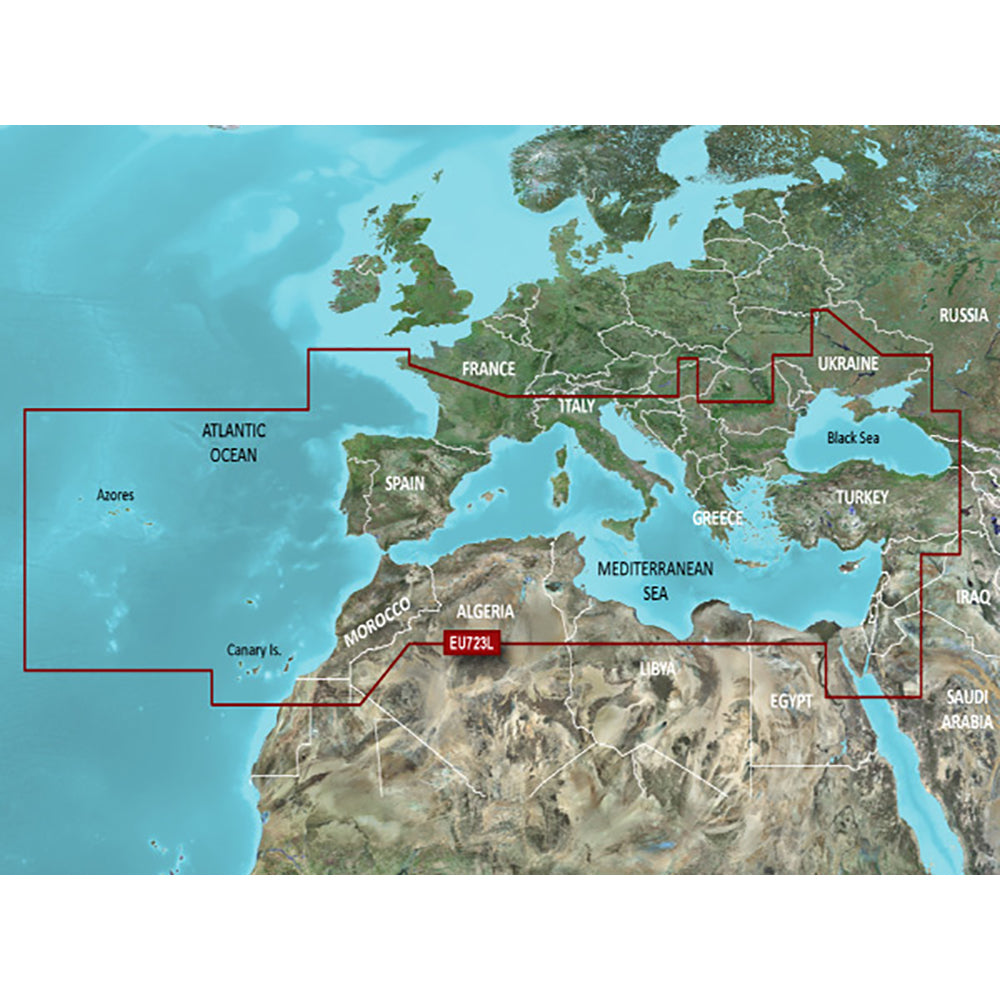
Coverage Area
This card covers the Mediterranean Sea, the Black Sea, and the Iberian Peninsula. Detailed areas include the Strait of Gibraltar, the Balearic Islands, the French Riviera, Corsica, Sardinia, Sicily, the Adriatic and Aegean Seas, the Greek Islands, the Sea of Azov, the Dardanelles and Bosporus straits, the Sea of Marmara, Cyprus, the Suez Canal, and selected inland waters. It also features the Atlantic side of the Iberian Peninsula, ranging from the Canary Islands to the Bay of Biscay, including the Portuguese coast, the Gulf of Gascogne, and the Madeira and Azores Islands.
Key Features
- Auto Guidance technology calculates suggested routes based on desired depth and overhead clearance.
- Depth Range Shading allows for viewing up to 10 distinct depth ranges for targeted navigation.
- 1-foot contours provide precise bottom structure depictions for improved fishing accuracy.
- Shallow Water Shading enables user-defined depth shading to highlight shallow areas.
- High-resolution satellite imagery with navigational overlays offers a realistic view of surroundings, especially when entering unfamiliar harbors.
- FishEye View and MarinerEye View provide 3-D perspectives of the surrounding area above and below the waterline.
- Includes high-detail aerial photography of many ports, harbors, and marinas.
Note: Auto Guidance is intended for planning purposes only and does not replace safe navigation practices.
Regulatory Notice: This product can expose you to chemicals known to the State of California to cause cancer, birth defects, or other reproductive harm. For more information, visit P65Warnings.ca.gov.
Product facts
- CT SKU
- CT-106380
- Model / MPN
- 010-C1157-00
- UPC / GTIN
- 753759205331
- Package dimensions
- " X 5" X 5"
- Package weight
- 0.1 lb
Shipping & returns
Shipping & returns
Shipping methods, delivery estimates, and final costs appear at checkout before payment. Some bulky, supplier-shipped, or special-handling items may ship separately. See Shipping & Returns for return windows and eligibility.
Fit & compatibility
Fit & compatibility
Review the product title, description, images, dimensions, part numbers, and manufacturer details before purchase. For fit-sensitive items, confirm compatibility with your boat, RV, trailer, vehicle, or equipment.
Need help choosing?
Need help choosing?
Send us the product link or SKU, plus details about your boat, RV, trailer, vehicle, or project. We will help you narrow down the right option when product fit is not obvious.