Brand: Garmin
Garmin Navionics+ NSAE016R Japan Lakes & Coastal Marine Chart
Garmin Navionics+ NSAE016R Japan Lakes & Coastal Marine Chart
Sold out
The Garmin Navionics+ NSAE016R provides detailed marine cartography for Japan and surrounding areas, compatible with select Garmin chartplotters. This all-in-one map solution combines coastal and inland content with high-resolution depth shading and navigation features for improved situational awareness.
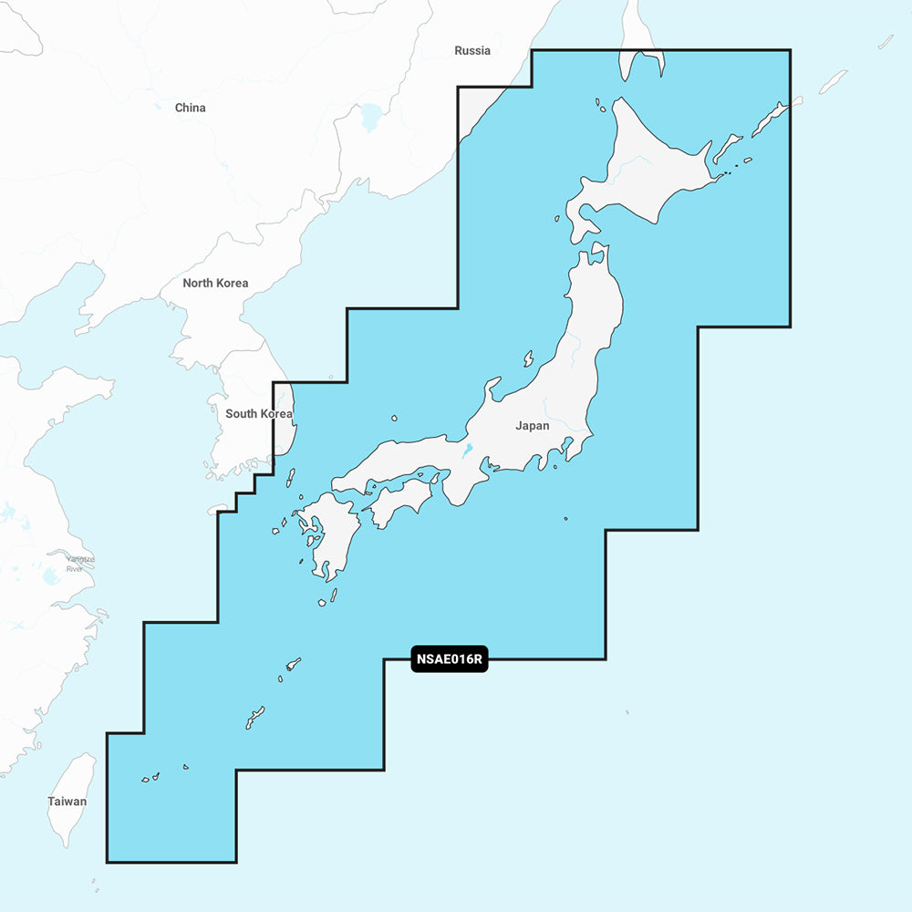
Coverage Area
Detailed coverage includes the coasts of Japan from the Yaeyama Islands to Aniva Bay and Kunashir Island, plus South Korean coastal coverage from Busan to Deoksan-ri. Inland maps cover major lakes such as Inawashiro, Kussharo, Ogawara, Onuma, Shikotsu, Shinji, Towada, and Toyako.
Key Features
- Up to 1' contours for detailed bottom structure
- Auto Guidance+ technology for suggested dock-to-dock routing
- High-resolution depth range shading with up to 10 user-selected color ranges
- Shallow water shading to assist in hazard avoidance
- ActiveCaptain community access for shared local POIs and navigation insights
- Includes a one-year subscription for daily chart updates via the ActiveCaptain app
Technical Specifications
- Format: MicroSD/SD card
- Model Identifier: NSAE016R
- Manufacturer Part Number: 010-C1215-20
Note: Auto Guidance+ is intended for planning purposes only and does not replace safe navigation practices. Please verify chartplotter compatibility before purchase.
Product facts
- CT SKU
- CT-111684
- Model / MPN
- 010-C1215-20
- UPC / GTIN
- 753759289096
- Package dimensions
- 1" X 1" X 6"
- Package weight
- 0.2 lb
Shipping & returns
Shipping & returns
Shipping methods, delivery estimates, and final costs appear at checkout before payment. Some bulky, supplier-shipped, or special-handling items may ship separately. See Shipping & Returns for return windows and eligibility.
Fit & compatibility
Fit & compatibility
Review the product title, description, images, dimensions, part numbers, and manufacturer details before purchase. For fit-sensitive items, confirm compatibility with your boat, RV, trailer, vehicle, or equipment.
Need help choosing?
Need help choosing?
Send us the product link or SKU, plus details about your boat, RV, trailer, vehicle, or project. We will help you narrow down the right option when product fit is not obvious.