Garmin
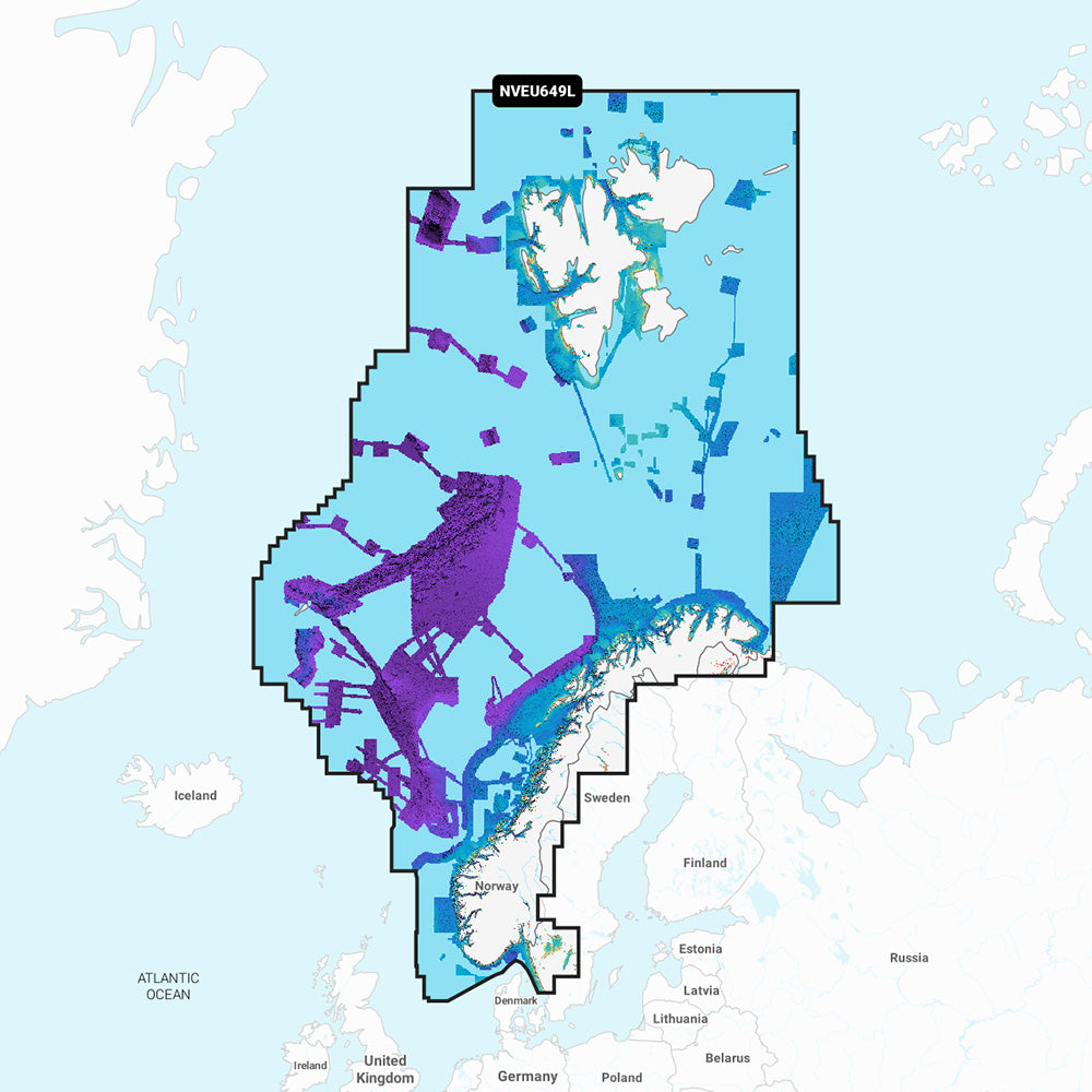
Garmin Navionics Vision+ NVEU649L Norway, microSD/SD Card
Garmin Navionics Vision+ NVEU649L Norway, microSD/SD Card
SKUCT-113353
Out of stock
Product details
Review the details before ordering.
Elevate your marine navigation with the Garmin Navionics Vision+ NVEU649L Marine Chart. This premium cartography solution provides unparalleled detail for the entire coast of Norway and significant parts of Sweden, combining the trusted accuracy of Navionics with Garmin's advanced features. Navigate intricate fjords, explore hidden coves, and pinpoint prime fishing spots with confidence, thanks to high-resolution imagery and intelligent routing. This essential charting tool transforms your compatible chartplotter into a powerful command center, ensuring safer and more efficient journeys. Upgrade your marine electronics today for an unmatched on-water experience.
In the Box:
- Garmin Navionics Vision+ NVEU649L microSD/SD Card
Key Features & Benefits:
- Extensive Coverage: Gain detailed mapping of the entire Norwegian coastline, including the Oslofjord, Sognefjord, Vestfjorden, Jan Mayen Island, and Svalbard, alongside key Swedish inland waters like Lakes Vänern and Vättern, and the Trollhätte and Göta Canals. Key ports like Gothenburg, Kristiansand, Bergen, and Trondheim are also covered.
- Superior Bottom Detail: Utilize up to 1-foot contours and advanced depth range shading with up to 10 color-shaded options to clearly visualize bottom structure and highlight target depths for fishing.
- Enhanced Situational Awareness: Benefit from high-resolution relief shading, satellite imagery, and crystal-clear aerial photography of ports, marinas, and landmarks for a better understanding of your surroundings both above and below the waterline.
- Advanced 3D Views: Experience a clearer perspective with 3D Fisheye and Marinereye views, providing immersive representations of underwater and surrounding areas.
- Intelligent Auto Guidance+: Plan your journey effortlessly with suggested dock-to-dock routing through channels, inlets, and marina entrances, taking into account your vessel's dimensions.
- Always Up-to-Date: Your purchase includes a one-year subscription for daily chart updates, accessible via the ActiveCaptain app, ensuring you always have the most current mapping data.
- Dynamic Lake Level Adjustment: For inland waters, adjust maps to current lake levels to assess accessibility and depth, especially useful for exploring new areas.
- ActiveCaptain Community: Access community-sourced content, including useful points of interest such as marinas, anchorages, and hazards.
Compatibility:
This Garmin Navionics Vision+ microSD/SD card is designed for use with a wide range of compatible Garmin GPS chartplotters, including various ECHOMAP™ UHD, ECHOMAP™ Ultra, and GPSMAP® series devices. Please verify compatibility with your specific chartplotter model to ensure full feature functionality.
Shipping & returns
Shipping & returns
Shipping methods, delivery estimates, and final costs appear at checkout before payment. Some bulky, supplier-shipped, or special-handling items may ship separately. See Shipping & Returns for return windows and eligibility.
Fit & compatibility
Fit & compatibility
Review the product title, description, images, dimensions, part numbers, and manufacturer details before purchase. For fit-sensitive items, confirm compatibility with your boat, RV, trailer, vehicle, or equipment.
Need help choosing?
Need help choosing?
Send us the product link or SKU, plus details about your boat, RV, trailer, vehicle, or project. We will help you narrow down the right option when product fit is not obvious.